Christoph from Switzerland, a guest of Chalo Travels, tells of his experiences of his three-week and 1200 km long bike journey through the Indian Himalayas from Shimla to Leh with a crowning ascent of the Stok Kangri at the end.

It hit me like a hammer.. When the sliding doors of Delhi airport opened, I was overwhelmed by the hot, sultry air with the peculiar smell. I was in India! The modern metro took me to the city centre. I walked to the nearby train station, past countless people who were scurrying around busy or just lying on the ground. Despite the sleepless night on the plane, I was very excited about the many new impressions and if everything would work out. For the first time in India and even outside Europe, I was excited to get to know such a foreign part of the world.

The train was air-conditioned and half empty, and we were served tea and food by attentive train attendants. I relaxed and looked out of the window. For miles we drove past the foothills of Delhi, poor huts and mountains of garbage, in between, cows that ran around freely. Then the houses stopped and the journey led through flat agricultural land with rice cultivation. In Kalka I changed trains, then a time-honoured narrow gauge railway led up into the mountains to Shimla. The train was very slow on this winding, bridge- and tunnel-rich route and I had time to watch the area and the other passengers, mostly Indian families on excursions. Everyone was very nice, interested and helpful.

It was raining in Shimla. I met Naresh, my driver and companion for the next two and a half weeks. We bought water and some food, then the bike tour started. The road led promisingly along the green mountains to Narkanda. I got to know the left-hand traffic and watched monkeys lined at the side of the road. Every now and then cows lay in the middle of the road and the numerous traffic curled around them. The next day, the first thing that followed was a long descent down into the Kinnaur valley. Pressing heat accompanied me for the next few hours. The valley of satluy became increasingly narrow and rising steadily. The landscape was still very green, from time to time the road was spectacularly carved out of the rocks. We stayed in Kalpa far above the valley floor to get used to the height. The next morning we arranged the Inner Line Permit to continue towards Spiti. This area is heavily controlled by the military due to its close proximity to the Chinese border.

The landscape became more and more exciting. Furthermore, the road followed the Satluj River, from Pooh the valley became more and more a gorge, with high rock faces on both sides. The area had become very dry, it only from time to time there were sparse bushes. Many curves and through a huge landslide we road up to Nako at 3600 meters.

Nako is located on a ridge by a small lake. It is a beautiful, ancient village with simple houses and traditional agriculture. After the days down in the valley floor I enjoyed the magnificent view of the mountains and huge gorges. Breathing was noticeably more difficult here, and sleep was only moderately relaxing.

A long descent led down to the valley to the Spiti River, which was followed by the road for the next few days. We were now in the Spiti Valley. The high mountains shielded the area from the clouds, it was hot and the sun was burning. Nothing grew here, just little directly on the river or on the irrigated fields. Again and again we passed columns of street workers who maintained the road with the simplest means. There were hardly any machines, almost all the work was done by hand by many people. Women in colored saris carried heavy stones around. In Tabo we were able to stay and eat with a local family thanks to Naresh. Together we looked at the famous old monastery in the village.

The next day followed a detour to Dhankar Monastery. A winding mountain road led up there and I tried to drive as gently as possible in order to get used to the height. The Indian roads are usually relatively flat, the inclines rarely more than 5%. What is probably due to the age-defying trucks also benefits the cyclists, who already have enough to contend with the enormous height.

Dhankar was beautiful! The old monastery is spectacularly situated on a rock, but due to this exposed location it is in danger of collapsing and no longer in operation. The monks now live in a large new building. Passing the great mountain village of Lalung we returned to the Spiti Valley and quartered in Kaza.

This was followed by an acclimatisation day with a trip to Komic Monastery, which is 4,500 metres high. A narrow, winding mountain road led up there, past the supposedly highest post office in the world, from where I sent some postcards. From above we had a magnificent view of the valley with the wide, undeveloped Spiti River, which flowed in countless arms and meanders. Such original river valleys hardly exist in Switzerland any more and I imagined what my homeland must have looked like before the canalization of the rivers. We reached a wide brown hilly landscape, surrounded by high mountains. Despite the high altitude, people live everywhere in small villages and, thanks to irrigation, fight off the dry soil with a barren livelihood.

But the water is becoming less and less due to the lack of rainfall, which threatens the future of these people. During the descent we got into a rain shower, which softened the loamy slope and made it very slippery. For me with the stud-tired mountain bike, however, this was a smaller problem than for Naresh in the car. Finally we returned to Kaza.

The further path was lined with impressive river landscapes. Numerous tributaries flowed to the Spiti, forcing the road into adventurous bypasses and bridges. The road condition became worse and worse. But it was beautiful! Sun and clouds illuminated an astonishingly colourful landscape with sometimes bizarre forms of erosion. Everything here was bigger, wilder and more original than at home. Shortly before the last village of Losar, a side river caused flooding and flooded the bridge. The water rose more and more, in a somewhat hectic action we grabbed the bike on the roof of the car and drove through the high water. Another highlight followed, the first high pass Kunzum La with a height of 4590 meters, which connects the Spiti valley with the Lahaul valley. The low sun bathed the mountain landscape in a magical light. Passing yaks and horses I climbed higher and higher until finally the stupa appeared at the pass height. I was happy to have mastered this first challenge and performed a little ritual with Naresh for the pleasure of the gods. As a Hindu, Naresh was very open-minded and by no means reluctant to visit and pray in the Buddhist shrines.

Another detour led us to the Chandra Taal, a magnificent mountain lake, located in a picturesque, misty-dreary basin and at the same time the source of the Chandra River. We stayed there in surprisingly comfortable, large tents and visited the lake the next morning. Since the Chandra Taal is sacred to Naresh, he filled some water from it and took it with him.
Now it was the first time that a valley went downhill. The piste in the Lahaul valley was poor and therefore really demanding and fun for biking! Again and again, landslides and creeks that flooded the road had to be mastered. The goal was to keep dry shoes, which was not easy on the sometimes longer sections due to rock-enhighed, surprisingly deep and cloudy water… But not only for me the route was difficult, also the numerous motorcyclists, cars and trucks fought with the elements. I came to the conclusion that a mountain bike was one of the most suitable means of transport on this route, in an emergency I could simply carry it over the most garish places. Naresh once got stuck with his car on a large boulder in the murky water of a creek, but with the combined forces of some motorcyclists we were able to quickly get the vehicle back on track. From the junction to the Rohtang La pass, which leads to Manali, the road became wide and asphalted, freed we rolled to Sissu.

We were now on the Manali-Leh Highway, the real reason for my trip. I had become aware of this route while researching the Internet and was fascinated by the high passes and vast landscapes it crosses. So now I was actually here and excited about what to expect. It went further down the valley, but of course not without some counter-climbs. Because of the slightly lower height of about 3000 meters I felt good and was able to drive a little faster. I was glad that I tolerated the differences in altitude and had already adjusted somehow. On a good road we passed Keylong and Jispa. The landscape was greener again and reminiscent of the Alps. At the bottom of the river were always wonderfully located tent complexes. From Darcha followed a longer ascent, the area became again barren. Through a magnificent mountain landscape, the road rose further and further, about the same as my strength disappeared. Finally we reached a tent camp above the Zing-Zing Bar, where we got something to eat and Naresh got us a comfortable night camp.

It continued uphill. Passing the throng of road workers who were living under tarpaulins along the construction sites in the simplest conditions, we reached the 4890 meter high Baralacha La Pass. The descent led us into a wild, colourful landscape with wide-ranging rivers and rugged mountains. After a while we reached the wide, flat river valley of the Tsarap. The river had , uncovered bizarre rock formations, which looked fascinating. In Sarchu we met for the first time the bike group of Sarah and Yogi, who also rode the Manali-Leh Highway. I was very happy about the company, and finally got to know Sarah, after we had only exchanged via email. Unfortunately I couldn’t stay and so followed another pass, the Nakee La. 22 hairpin bends, the Gata Loops, led up there. For me it was quite a path of suffering, obviously I was now making up for the long and strenuous stage the day before. The problem was that I could hardly recover during the nights at these enormous heights, in the morning I was usually just as broken as the evening before…

From Pang, the road climbed up to a massive plateau, the Morey Plains. This plain is about 40km long and lies at an altitude of 4800 metres. With tailwinds we made quite good progress. In front of us another pass piled up, the Tanglang La. The road was quite new and very well developed, moreover not particularly steep. But the wind had turned against us and I felt bad. Slowly I worked my way on the 5328 meter high pass, supposedly the second highest in the world. Up the pass, the feelings of happiness flowed in streams! A large group of Indian motorcyclists dressed in pink had also arrived and held a cheerful photo shoot. We rode down the road again and turned towards Thugje near the white Salt Lake Tso Kar. Unfortunately, I had to say goodbye to Naresh, who was not allowed to travel the following route. Dorje, also a friendly and helpful driver from Leh, took his place, but unfortunately I could only communicate rudimentarily.

My path led me deeper into the Changthang region of Ladakh, a foothill of the Tibetan plateau. The area is about 4500 meters high and desert-like barren. Due to the extremely dry air, the view and colours were overwhelmingly beautiful! There are several deep blue lakes in the area, which are framed by the light brown environment. We drove a rough dust track, which leads over two smaller passes and past colored sulfur springs to the Tso Moriri, a large lake with some picturesque six-thousand-metre mountains around it. On its west bank there is a small village where we spent a day of breaks A local, Sonam, led me to a nomadic camp where the inhabitants live in tents, and to a small mountain with fantastic views of the lake and the snow-capped peaks behind it.

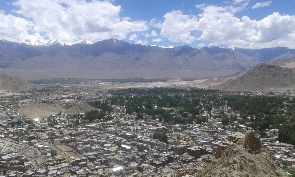
After this detour, the route led down to the Industal. The river carried a lot of water and flooded the road in some places, requiring some bypasses and wading maneuvers. The route was characterized by varied shapes, colours and street conditions. Places with impeccable asphalt ceilings alternated with long, dusty construction site sections. The violence of the raging river was impressive, again and again we passed flooded gardens and fields. In Upshi, the road hit the Manali-Leh Highway. In vain I tried to get a comfortable accommodation. Finally, in the dark, we drove in the car to Leh, where we met Sarah’s group again and I was able to stay in the Jigmet Guesthouse. The bike tour was over, but not the experiences.

Together with Sarah’s group, I rode to Khardung La, supposedly the highest pass on earth. And with Sarah and Yogi I was able to take a three-day mountain tour to the 6125 meter high Stok Kangri. After that it was enough…

Christoph, 45-year-old bicycle mechanic from Switzerland
Thank you Sarah for your help in planning and organizing this magnificent tour! I don’t know if I would have dared to do it without your help. Your preparations and the accompanying vehicle have given me a lot of room for manoeuvre and safety. It all worked like a string.


